This reserve is managed, from 2008, through an agreement between FNyH, the Neighborhood council of Gajano, Marina de Cudeyo Town Hall, and a concession of Coast Demarcation in Cantabria.
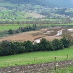
The reserve is located at the head of the Ria de Tijero. Its boundaries are defined by the Bay of Santander to the northwest and the town of Gajano to the north, specifically the neighborhoods of El Torrejón and El Puente. South borders the farm Heras and the road A-8. East, the Mount Abejo is the geographical boundary, near the Pozón of Yesera.
This reserve has two very different ecological units with a common characteristic, both are part of a riparian ecosystem. The first unit is the head of the Ría de Tijero, formed by an intertidal area populated by salty pasture and halophytic vegetation subject to ponding caused by tidal dynamic. However, the river banks are populated by reeds in areas of shallow water as well as riparian vegetation in areas not directly exposed to flooding. One of the most frequent tree species present in the river banks is the tamarisk, accompanied by chilca where water splashes produce a saline environment.
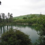
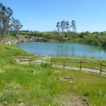
The second unit corresponds to Pozón de la Yesera. This is a wetland originated from a gypsum mining exploitation, active until the mid-70s of the twentieth century. The continued extraction of mineral produced the upwelling of the water table and, as a consequence, a lagoon was formed. Close to Pozón, it is located the creek Romanillo, one of the streams that provide fresh water to the Ría de Tijero. This stream presents typical species of river banks, among them highlight willows, hazel, eucalyptus and black locust.
After the abandonment of mining Pozón, it began the naturalization of the area that subsequently led to the emergence and spread of pampas grass and illegal discharge of debris and other waste.
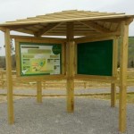
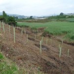
The project “Environmental Restoration of the head of the Ría de Tijero y del Pozón de la Yesera (2009)” has led to the removal of debris, the recovery of the water level and the incorporation of native trees to compete with pampas grass (Cortaderia selloana) and the conditioning of a small network of trails for the public use of the area.
Partners
- Neighborhood council of Gajano
- Ministry of Agriculture, Food and Environment. Coast Demarcation in Cantabria
- General Direction of Sustainability of the Coast and the Sea
- Counselling of the Environment of the Regional Government of Cantabria
<iframe src=”https://www.google.com/maps/d/embed?mid=zmP4mtNhSVhk.k8OaGxSlA-pM” width=”640″ height=”480″></iframe>